|
1982.
M.Sc., 178 pp.
TIDAL SEDIMENTATION IN NORTHWESTERN AKIMISKI STRAIT, JAMES BAY,
ONT.
Grinham,
D.F.
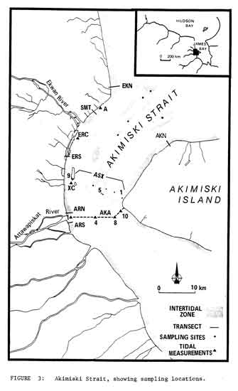
 Akimiski
Strait is a shallow emergent waterway in south-western James Bay.
Sedimentation within the Strait is controlled by longshore tidal current
generated by opposing tidal waves, and by the formation and removal of sea
ice. Sediments are primarily derived from erosion of shallow subtidal reaches
intertidal shoals and intertidal flats, and from the discharge of the Ekwan
and Attawapiskat rivers. Intertidal
shoals, the erosional remnants of glacial deposits, are winnowed by tidal
currents and waves. The height of these shoals is main- tained by current
scouring of inter-shoal swales, intensified when ice covers the exposed
surfaces. The tidal flats of the
eastern (Akimiski Island) shore are broad and gently sloping. Till is exposed
on the lower tidal flat, but is covered by fine sediments on the high flat.
Sedimentation is slow on this coast, due to the wave stirring of bottom
material in the shallow water at peak flood tide and the prolonged ice cover. Tidal flats of the mainland shore are steep and narrow, with
rapid net sedimentation. South of the Ekwan River, emerging intertidal shoals
close to shore lead to the development of unusual tidal channels. These
channels veer inland across the salt marsh, turn to run parallel to the coast
for several kilometers and finally return to the Strait. Reversing longshore
tidal currents keep the channels open well inland.
Circulation patterns and sediment dispersal are radically altered by
sea ice. At breakup, the northern entrance of Akimiski Strait is blocked,
transforming the Strait into an 'ice-walled embayment'. Much of the spring
suspended sediment load of the Ekwan and Attawapiskat rivers is deposited on
the mainland coast. On the
northwest Akimiski Strait, an elongated shoal lies close to, and parallels the shore, modifying local hydrology by
channelizing southward flood currents shoreward and deflecting northward ebb
currents seaward. Three
depositional facies can be distinguished on this coast: Mainland Flats (divided
into an uppermost salt marsh, upper flat, lower flat, and tidal creek: Tidal
Channels (divided into erosional intertidal and depositional subtidal
sections); Ekwan Shoal. Each facies is characterized by distinctive mor-
phology, surface structures, and preserved internal structures.
The sedimentary model of this coast includes a landward fining in grain
size, and a landward gradation of sedimentary structure associations changing
from domination by alternating bedload and suspension domination. The mainland
flats are steeper than flats of other locations reported in the literature,
because of the sustained current erosion at the toe of
the lower flats and control on the upward growth of flats by isostatic
up- lift. Three characteristics
of this sequence are not common to other tidal flats reported in the
literature. Macrobenthos are unable to colonize the mainland flats due to the
lengthy exposure of upper parts, and the very soft, fine textured sediments of
the lower parts. Structures formed by ice action are preserved, including
'diffuse' sand lenses (in which sands fine out- wards from a granule or pebble
core) a structure not previously described in the intertidal environment.
Massive beds are preserved across the inter- tidal zone, forming in response
to several processes: mud flows on steep parts of the mainland flats; rapid
sedimentation from sediment charged water; and thawing and liquefaction of
surface sediments. Akimiski
Strait is a shallow emergent waterway in south-western James Bay.
Sedimentation within the Strait is controlled by longshore tidal current
generated by opposing tidal waves, and by the formation and removal of sea
ice. Sediments are primarily derived from erosion of shallow subtidal reaches
intertidal shoals and intertidal flats, and from the discharge of the Ekwan
and Attawapiskat rivers. Intertidal
shoals, the erosional remnants of glacial deposits, are winnowed by tidal
currents and waves. The height of these shoals is main- tained by current
scouring of inter-shoal swales, intensified when ice covers the exposed
surfaces. The tidal flats of the
eastern (Akimiski Island) shore are broad and gently sloping. Till is exposed
on the lower tidal flat, but is covered by fine sediments on the high flat.
Sedimentation is slow on this coast, due to the wave stirring of bottom
material in the shallow water at peak flood tide and the prolonged ice cover. Tidal flats of the mainland shore are steep and narrow, with
rapid net sedimentation. South of the Ekwan River, emerging intertidal shoals
close to shore lead to the development of unusual tidal channels. These
channels veer inland across the salt marsh, turn to run parallel to the coast
for several kilometers and finally return to the Strait. Reversing longshore
tidal currents keep the channels open well inland.
Circulation patterns and sediment dispersal are radically altered by
sea ice. At breakup, the northern entrance of Akimiski Strait is blocked,
transforming the Strait into an 'ice-walled embayment'. Much of the spring
suspended sediment load of the Ekwan and Attawapiskat rivers is deposited on
the mainland coast. On the
northwest Akimiski Strait, an elongated shoal lies close to, and parallels the shore, modifying local hydrology by
channelizing southward flood currents shoreward and deflecting northward ebb
currents seaward. Three
depositional facies can be distinguished on this coast: Mainland Flats (divided
into an uppermost salt marsh, upper flat, lower flat, and tidal creek: Tidal
Channels (divided into erosional intertidal and depositional subtidal
sections); Ekwan Shoal. Each facies is characterized by distinctive mor-
phology, surface structures, and preserved internal structures.
The sedimentary model of this coast includes a landward fining in grain
size, and a landward gradation of sedimentary structure associations changing
from domination by alternating bedload and suspension domination. The mainland
flats are steeper than flats of other locations reported in the literature,
because of the sustained current erosion at the toe of
the lower flats and control on the upward growth of flats by isostatic
up- lift. Three characteristics
of this sequence are not common to other tidal flats reported in the
literature. Macrobenthos are unable to colonize the mainland flats due to the
lengthy exposure of upper parts, and the very soft, fine textured sediments of
the lower parts. Structures formed by ice action are preserved, including
'diffuse' sand lenses (in which sands fine out- wards from a granule or pebble
core) a structure not previously described in the intertidal environment.
Massive beds are preserved across the inter- tidal zone, forming in response
to several processes: mud flows on steep parts of the mainland flats; rapid
sedimentation from sediment charged water; and thawing and liquefaction of
surface sediments.
|