|
1996. M.Sc., 278 pp.
BAR SEDIMENTATION AT THE HEAD OF THE ESTUARY OF THE
MOOSE RIVER. NORTHERN ONTARIO
Poehlman, T.
 The
upper reaches of the Moose River estuary have been analysed in terms of the
present and past fluvial and sediment dynamics under winter, spring and summer
conditions. More specifically, the geometry of this environment was defined,
the processes affecting it were identified and measured, the materials
transported through it and deposited within it were analysed, the facies that
characterize it were identified, and the human activities affecting it were
identified and qualified. The information acquired through this study may be
used for future management strategies designed for this area. The
upper reaches of the Moose River estuary have been analysed in terms of the
present and past fluvial and sediment dynamics under winter, spring and summer
conditions. More specifically, the geometry of this environment was defined,
the processes affecting it were identified and measured, the materials
transported through it and deposited within it were analysed, the facies that
characterize it were identified, and the human activities affecting it were
identified and qualified. The information acquired through this study may be
used for future management strategies designed for this area.
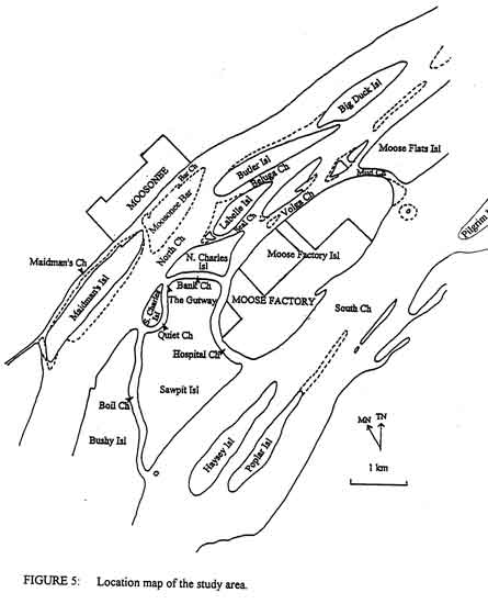
The upper estuarine reaches of the Moose River exhibit an anastomosing
geometry with 2 main channels (the North Channel with a well defined broadly
meandering thalweg) and the South Channel which lacks a well defined thalweg)
which contain numerous shoals I and emerging bars and a network of
longitudinal and transversal secondary channels separated by vegetated
islands. The river itself is bound by high (up to 4 m) and steep I (near
vertical) banks.
The main natural factors acting within this environment are fluvial
flow, tides (up to a tidal range of 2 m) from James Bay, isostatic uplift (up
to 1 m/century), and
meteorological
conditions. The
summer fluvial current velocities reach a maximum of 1.9 I rn/s in the thalweg
of the North Channel. However, flow in this reach is highly variable in part
due to the tidal influence from James Bay, which acts as a dam against the
fluvial flow I and forces water back up the estuary every 6 hours. Although
the salt wedge does not extend as far as Moosonee, the tidal influence is felt
as a change in water level (1 to 2 m) and a complete reversal of fluvial
current direction. Meteorological conditions such as wind can enhance or
almost eliminate either the flood or ebb stage of the tidal cycle depending on
its magnitude and orientation. In the study area, there is both a
geomorphological slope (channel bed) and a hydraulic slope which is set up
from the South Channel to the North Channel. This results in the transfer of
water from the South to the North Channel via transversal secondary channels.
The materials deposited in the upper reaches of the Moose River estuary
are I predominantly sand. Some
fines (mud) can be found in a few secondary channels. Tyrrell Sea clay
substratum is typically exposed near the banks of Moosonee and some secondary
channels. There are also areas of poorly sorted sandy gravel (ice rafted
accumulations). Open work gravel
is rare and only found in some shoals and the uppermost measured part of the
North Channel. Material in transport through the upper reaches of the estuary
is greatest during the spring freshet and lowest during the summer although
variable fluvial conditions during the summer can result in highly variable
local sediment transport rates. Migrational bedforms (dunes) and bars dominate
the channel floors. Island growth is in a downstream direction with the
development of sand bars such as the Moosonee Bar. The , surficial morphology
of the Moosonee Bar is dominated by sandwaves with superimposed ripples. Ice rafted material is preferentially deposited and later
reworked at the upstream end of the bar while cohesive fines (mud drapes)
blanket much of the downstream end. Vegetation is already stabilizing selected
areas (those of higher elevation) of the bar thereby encouraging its
development into an island.
The human activities affecting this environment include bank
deforestation and degradation, shoreline protection, dredging, gravel
excavation, transportation, flow regulation, and chemical loading. The already
steep banks which are naturally susceptible to failure are weakened further by
the removal of stabilizing vegetation and loading by buildings and traffic
along the shores of the communities of Moo so nee and Moose Factory. In an
attempt to protect property from future loss, extensive shoreline protection
structures have been built at the town sites. These, however, have locally
acted to transfer the erosion problem to nearby unprotected banks. The
material eroded from the banks is then added to the already shallow channels
of the upper estuary. Dredging and gravel excavation can locally modify flow
conditions by changing the channel geometry. Flow regulation by dams upriver
from Moosonee can be felt in the upper estuary of the Moose River. Chemical
loading may be a future problem given present population growth trends of Moo
so nee and Moose Factory. At the present time, however, the analysis of cores
taken from selected sites where fine material was deposited indicated no major
chemical contamination of the sediment.
In considering the development of the shallow and anastomosing
conditions of the upper estuarine reaches of the Moose River independently of
any human activity, the vital transportation routes presently used by the
inhabitants of Moo so nee and Moose Factory will become increasingly hazardous
as shallowing of the channels increases due to natural circumstances (isostatic
uplift and the progressive capture of the flow of the South Channel by the
North Channel).
|