Geogr. Ann. 63A(1981), 81-94
MORPHOLOGY AND SEDIMENTS OF THE EMERGENT ONTARIO COAST OF JAMES BAY, CANADA
I.P. MARTINI
Dept. Land Resource Science, University of Guelph, Guelph, Ontario, Canada
Ontario is a maritime province, although this is not commonly realized. It
has more than 2500 km of coasts along the Great Lakes and 1130 km along the
brackish waters of James and Hudson Bay. The coasts are underlain by a variety
of bedrock types, from hard crystalline Precambrian igneous and metamorphic
rocks, to Paleozoic soft shales and fractured carbonates. The shores of James
Bay in particular are rapidly emerging (70-100 cm/century) as response to
residual post-glacial isostatic rebound. 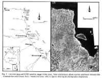 The shores are flat (order of 0.5-1.0
m/km), and because of their northern trend they contain the transition from a
southern forested, permafrost-free area to a northern tundra area with
continuous permafrost. These coasts enclose one of the largest wetlands of the
world, the Hudson Bay Lowland, where sequences of forested beach ridges and old
promonotories record the different stages of Holocene emergence of the land.
Shallow wide embayments mostly underlain by marine clay of an early post-glacial
Tyrrell sea have been occupied by large river throughout the Holocene.
The shores are flat (order of 0.5-1.0
m/km), and because of their northern trend they contain the transition from a
southern forested, permafrost-free area to a northern tundra area with
continuous permafrost. These coasts enclose one of the largest wetlands of the
world, the Hudson Bay Lowland, where sequences of forested beach ridges and old
promonotories record the different stages of Holocene emergence of the land.
Shallow wide embayments mostly underlain by marine clay of an early post-glacial
Tyrrell sea have been occupied by large river throughout the Holocene.
The Hudson-James Bay is
one of the largest inland seas of the world. James Bay has cold brackish waters
that are often renewed by large amounts of fresh water discharged by rivers, and
by marine water exchanged with the Hudson Bay. Ice covers the area for
approximately six months of the year, and pack-ice may be driven by wind against
northern Ontario shores well into July.
No single coastal feature
is unique to this area, but associations of features are very much so. The shore
of James Bay can be subdivided into four major tracts:
1) the coast south of the
Albany River is characterized by long narrow promonotories, wide sandy bays and
embayments occupied by major rivers;
2) the coast between the Albany River and Ekwan Point is ,
sheltered by Akimiski Island and has wide silty tidal flats and marshes;
3) the coast between Ekwan Point and Lake River has wide
promonotories and bays. It is characterized by locally well developed, long
beach ridge systems. Contrary to southern zones, Tyrrell sea clay is absent, and
till constitutes the substratum everywhere;
4) the coast north of Lake River has long sandy beaches, and
spits some of which enclose silty lagoons. Foredunes, blowouts, and deflation
surfaces are common features of this northern tundra area.
