![]()
![]()
![]()
![]()
![]()
![]()
|
|
|
Sedimentary Geology, 37(1983/1984), 251-272 SEDIMENTARY CONDITIONS AND DEPOSITS OF AKIMISKI STRAIT, JAMES BAY, CANADA I.P. MARTINI and D.F. GRINHAM Department of Land Resource Science, University of Guelph, Guelph, Ont. N1G 2Wl (Canada) Akimiski Strait is a wide (17-20 km), shallow, emergent (0.70 cm per century) waterway in James Bay. It is localized in a saddle of a Paleozoic reef track, which has been enhanced and molded by Pleistocene glaciers. Drumlinoid ridges form the till cores of shoals and islets of the strait. The boundary conditions of the strait change throughout the year, as it is 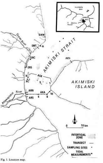 covered by ice for six months. During spring break-up the strait remains
clogged with ice at its northern approach for several weeks, and acts as a
large tidal inlet. It is during this period that most of the fluvial
sediments are carried to sea. Other sediments are obtained by erosion of
the Pleistocene tills and Holocene subtidal clays and silts exposed in
nearshore areas. Resuspension of nearshore material is achieved through
the action of wind-driven, short choppy waves and ice scour. Tides are the
most important process for the redistribution of sediments along the
coast, both flooding onshore and flooding and ebbing into and out from the
strait generating locally powerful (2 m s-1) reversing
currents. Ice rafting and ice pushing are important processes in this
frigid environment, particularly in upwind sides of shoals, and at/or near
river mouths. covered by ice for six months. During spring break-up the strait remains
clogged with ice at its northern approach for several weeks, and acts as a
large tidal inlet. It is during this period that most of the fluvial
sediments are carried to sea. Other sediments are obtained by erosion of
the Pleistocene tills and Holocene subtidal clays and silts exposed in
nearshore areas. Resuspension of nearshore material is achieved through
the action of wind-driven, short choppy waves and ice scour. Tides are the
most important process for the redistribution of sediments along the
coast, both flooding onshore and flooding and ebbing into and out from the
strait generating locally powerful (2 m s-1) reversing
currents. Ice rafting and ice pushing are important processes in this
frigid environment, particularly in upwind sides of shoals, and at/or near
river mouths.Different intertidal sedimentary sequences develop as functions of sediment supply and exposure of the environments to ice, currents and waves. The eastern shores and the southern shoals of the strait develop pebble lags over till, overed by thin (5-20 cm) drapes of silty sand trapped and protected from erosion by algae. In these shores and in emerging small islands significant sedimentation (1-1.5 m thick) occurs in the marshes where the suspended load of tidal waters is trapped by vegetation. The western shores of the strait receive considerable amounts of sediment from large rivers and are affected by strong tidal longshore currents. Thick (3-4 m) and narrow tidal flats and marshes develop on the main coast. The shoals of the northern part of the strait have characteristic sediments. Those near the western shore have thin (up to 80 cm) tidal silty sand deposits, locally heavily burrowed by Macoma balthica. Those strung across the northern approach to the strait have well-developed, thin, coarse sand dune fields, indicating a prevalent ebb flow out of the strait.
|
|
|