|
Sedimentary Geology, 37 (1984), 295-320
MORPHOLOGY AND RECENT SEDIMENTS OF THE LOWER ANASTOMOSING REACHES OF THE ATTAWAPISKAT RIVER,
JAMES BAY, ONTARIO, CANADA
W.A. KING and I.P. MARTINI
Department of Land Resource Science, University of Guelph, Guelph, Ont. N1G 2Wl (Canada)
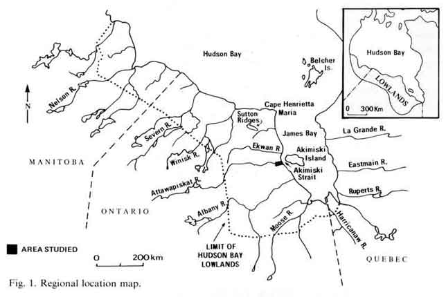
 The Attawapiskat River is one of the major low-gradient rivers that cross the flat wetlands of the Hudson Bay Lowland.
It has a nival regime leading to strong, short-duration spring floods during which considerable amount of sediment is carried.
For the remainder of the year only organic matter is transported in solution and suspension. The land is isostatically
rebounding after the Pleistocene glaciations. The river downcuts through the softer Holocene estuarine basal clays and
the Pleistocene tills, to the Paleozoic carbonate bedrock. The river develops an anastomosing pattern in the lower reaches
and it acquires an irregular meandering character inland. It does not construct a significantly thick delta as the river-borne
sediments are dispersed along the coasts by tides, longshore currents and ice rafting. The river is subjected to frequent ice
jams in its lower reaches as warmer southern waters flow toward the still frozen mouth and sea. During the jams, secondary
channels become active, floodings develop and sedimentation occurs on the levees. Ice scours and ice-rafted materials affect
the riverbanks greatly. The Attawapiskat River is one of the major low-gradient rivers that cross the flat wetlands of the Hudson Bay Lowland.
It has a nival regime leading to strong, short-duration spring floods during which considerable amount of sediment is carried.
For the remainder of the year only organic matter is transported in solution and suspension. The land is isostatically
rebounding after the Pleistocene glaciations. The river downcuts through the softer Holocene estuarine basal clays and
the Pleistocene tills, to the Paleozoic carbonate bedrock. The river develops an anastomosing pattern in the lower reaches
and it acquires an irregular meandering character inland. It does not construct a significantly thick delta as the river-borne
sediments are dispersed along the coasts by tides, longshore currents and ice rafting. The river is subjected to frequent ice
jams in its lower reaches as warmer southern waters flow toward the still frozen mouth and sea. During the jams, secondary
channels become active, floodings develop and sedimentation occurs on the levees. Ice scours and ice-rafted materials affect
the riverbanks greatly.
The principal sedimentary environments within the river consist of: (1) erosional shoals covered by boulder
and pebble lags over till; (2) sorted coarse to medium-sized sands in junction bars downstream from islands: these sands frequently
develop gas bubbles, and they contain characteristic fining-upward sequences from boulder pavements at the base, grading up into
rippled sand with abundant organic matter, grading up into laminated silt and sand and organic matter; (3) secondary channels,
which develop thin silty and clay drapes on eroded hard substratum and are filled eventually by thick peat: and (4) river bank
which show well-developed regressive sequences from Pleistocene tills at the base, overlain by estuarine sparsely fossiliferous
clays, capped by thin conglomeratic units with abundant reworked Macoma balthica shells, grading upward into upper tidal flat sand,
irregularly laminated sand and silt of marshes, and regular interbedding of sand, silt and organic layers of the levees at the top.
|