|
Sedimentology, 44 (1997), 197-220
ANATOMY AND EVOLUTION OF A LOWER CRETACEOUS
ALLUVIAL PLAIN: SEDIMENTOLOGY AND PALAEOSOLS IN THE UPPER
BLAIRMORE GROUP,
SOUTH-WESTERN ALBERTA, CANADA
PAUL J. MCCARTHY1, I. PETER
MARTINI1 and DALE A. LECKIE2
1Department
of Land Resource Science, University of Guelph, Guelph, Ontario, Canada N1G 2W1
2Institute of Sedimentary and
Petroleum Geology, Geological Survey of Canada, 3303-33rd St., N.W., Calgary,
Alberta, Canada T2W 2A7
 The Lower Cretaceous (Albian) upper
Blairmore Group is part of a thick clastic wedge that formed adjacent to the
rising Cordillera in south-western Alberta. Regional transgressive intervals are
superimposed on the overall regressive succession. Alluvial conglomerates,
sandstones and mudstones were deposited in east-northeastward draining fluvial
systems, orientated transverse to the basin axis. Five facies associations have
been identified: igneous pebble conglomerate, thick sandstone, interbedded
lenticular sandstone and mudstone, thick mudstone with thin sandstone
interlayers, and fossiliferous sandstone and mudstone. The facies associations
are interpreted as gravelly fluvial channels, sandy fluvial channels,
sand-dominated floodplains, mud-dominated floodplains, and marine shoreline
deposits, respectively. The Lower Cretaceous (Albian) upper
Blairmore Group is part of a thick clastic wedge that formed adjacent to the
rising Cordillera in south-western Alberta. Regional transgressive intervals are
superimposed on the overall regressive succession. Alluvial conglomerates,
sandstones and mudstones were deposited in east-northeastward draining fluvial
systems, orientated transverse to the basin axis. Five facies associations have
been identified: igneous pebble conglomerate, thick sandstone, interbedded
lenticular sandstone and mudstone, thick mudstone with thin sandstone
interlayers, and fossiliferous sandstone and mudstone. The facies associations
are interpreted as gravelly fluvial channels, sandy fluvial channels,
sand-dominated floodplains, mud-dominated floodplains, and marine shoreline
deposits, respectively.
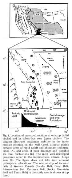
Five types of palaeosols
are recognized in the upper Blairmore Group based on lithology, the presence of
pedogenic features (clay coatings, root traces, ferruginous nodules,
slickensides, carbonate nodules) and degree of horizonization. The regional
distribution of the various types of palaeosols enables a refinement of the
palaeoenvironmental reconstruction permitting an assessment of the controls on
floodplain evolution. In source-proximal areas, palaeosol development was
inhibited by high rates of sedimentation. In source-distallocations, poor
drainage resulting from high watertables, low topography and lower rates of
sedimentation also inhibited palaeosol development. The best-developed
palaeosols (containing Bt horizons) occur in intermediate alluvial plain
positions (tectonic hinge zone) where the floodplains were most stable due to a
balance between sedimentation, erosion and subsidence rates. Extrapolating from
the upper Blairmore Group suggests that the tectonic hinge zone of continental
fore-land basins can be established by palaeosol analysis. At the hinge zone,
soil development is controlled primarily by climate and tectonics and their
effect on sediment supply, whereas closer to the palaeoshoreline, relative sea
level fluctuations, resulting in poor drainage, may have a more significant
influence.
|