|
Spec. Publ. Int. Ass. Sediment, 32(2002),
213-231
COARSE-GRAINED FLOOD BARS FORMED AT THE
CONFLUENCE OF TWO SUBARCTIC RIVERS AFFECTED
BY HYDROELECTRIC DAMS, ONTARIO,
CANADA
S.-J. MOSHER and I.P. MARTINI
Department of Land Resource Science,
University of Guelph, Guelph, Ontario, Canada N1G 2W1
 This paper illustrates the morphological
changes produced in subarctic streams by regulated floods released from
hydroelectric dams, and analyses sedimentologically the gravelly flood bars
formed at the confluence of two streams in northern Ontario. Subarctic rivers
have nival regimes, where strong floods occur during spring snow-melting and low
flows for the rest of the year. Northern Ontario is a relatively flat region,
and artificial reservoirs are not sufficiently large to retain the spring
floodwaters nor, in most cases, can the waters be released through the turbines
into the main stream. Instead, spillways are built, through which floodwaters
bypass the hydroelectric stations, rejoining the main river downstream. In 1963,
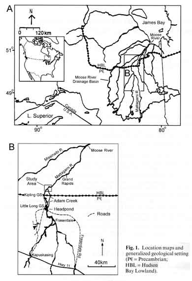
excess water in the headpond of the Mattagami River hydroelectric complex was
spilled for the first time along the small (25 m wide and a few metres deep),
meandering Adam Creek. Since then, regulated spring-flood discharges through the
creek have averaged approximately 2100 m3 S-I, with a few floods exceeding 4000
m3 S-I. Adam Creek has experienced severe erosion along its lower reaches, which
are underlain by Quaternary glacial deposits and poorly cemented, Mesozoic,
clastic rocks. Approximately 52 x 106 m3 of sediment have been eroded and a
canyon about 200 m wide and up to 30 m deep has developed. Approximately 2.5 x
106 m3 of this eroded material, predominantly the coarse fraction (boulders to
coarse sand), have been retained in a junction bar and in three alternating side
bars that have developed along a 5-km reach of the mainstream (Mattagami River)
at and immediately downstream from the confluence with the Adam Creek spillway.
The erosion of the spillway, the formation of the coarse-grained bars and the
related local narrowing and deepening of the main river may have developed
rapidly during the first few floods; subsequent floods have modified the surface
structures (chutes, secondary channels, terraces) of the bars. This paper illustrates the morphological
changes produced in subarctic streams by regulated floods released from
hydroelectric dams, and analyses sedimentologically the gravelly flood bars
formed at the confluence of two streams in northern Ontario. Subarctic rivers
have nival regimes, where strong floods occur during spring snow-melting and low
flows for the rest of the year. Northern Ontario is a relatively flat region,
and artificial reservoirs are not sufficiently large to retain the spring
floodwaters nor, in most cases, can the waters be released through the turbines
into the main stream. Instead, spillways are built, through which floodwaters
bypass the hydroelectric stations, rejoining the main river downstream. In 1963,
excess water in the headpond of the Mattagami River hydroelectric complex was
spilled for the first time along the small (25 m wide and a few metres deep),
meandering Adam Creek. Since then, regulated spring-flood discharges through the
creek have averaged approximately 2100 m3 S-I, with a few floods exceeding 4000
m3 S-I. Adam Creek has experienced severe erosion along its lower reaches, which
are underlain by Quaternary glacial deposits and poorly cemented, Mesozoic,
clastic rocks. Approximately 52 x 106 m3 of sediment have been eroded and a
canyon about 200 m wide and up to 30 m deep has developed. Approximately 2.5 x
106 m3 of this eroded material, predominantly the coarse fraction (boulders to
coarse sand), have been retained in a junction bar and in three alternating side
bars that have developed along a 5-km reach of the mainstream (Mattagami River)
at and immediately downstream from the confluence with the Adam Creek spillway.
The erosion of the spillway, the formation of the coarse-grained bars and the
related local narrowing and deepening of the main river may have developed
rapidly during the first few floods; subsequent floods have modified the surface
structures (chutes, secondary channels, terraces) of the bars.
|