|
Journal of
Coastal Research, 43, (2004), 179-201.
APPLICATION OF
GROUND-PENETRATING RADAR FOR SPIT STRATIGRAPHIC INTERPRETATION, HAINAN ISLAND,
CHINA
Yong Yin1,
Da-kui Zhu1,
I.P. Martini 2, Wen-wu
Tang1 and Ye-hua Xu1
1The Key Laboratory of Coast and
Island Development, Nanjing University, Nanjing, 2100093, China
2Dept. Land Resource Science,
university of Guelph, Ontario, Canada, N1E 4E5
Sandy tropical beaches worldwide are experiencing
ever-increasing development pressure for, among others, habitations, tourism
facilities, aquaculture. This is particularly excruciating in coastal areas of
China, which have been inhabited since antiquity. Hainan Island, in south China,
is a case in point with the add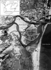 ed
preoccupation that some of its sandy coasts have been mined for heavy mineral
placers. In this study the standard geomorphic and stratigraphic techniques
have been augmented by extensive Ground-penetrating Radar (GPR) surveys to
establish both the natural evolution of a long estuary-mouth barrier/barrier
spit and its anthropogenic features. The barrier is located along the east shore
of the island. Stratigraphic and GPR evidence indicates that this is a Upper
Pleistocene--Holocene purely transgressive barrier in its northern half where
the powerful Wanquan River was able to remove most of the pre-Last Glacial
Maximum (LGM) costal deposits. In its southern half where deposits of previous
Pleistocene transgressive--regressive cycles remain as substrate obstructions,
the barrier is a transgressive feature that has reversed to a regressive one
during the Holocene high stand. Further to the geometries of the upper 6-12 m of
the succession, which allow detection of the landward and seaward accreting
layers, the GPR can establish the presence of concave upward discontinuities
associated with irregular-reflector radar facies, which indicate both the
presence of fluvial channels in the back-barrier area and human workings on the
barrier itself, such as backfilling of mining pits. Other characteristics of the
GPR response, such as various parabolic reflectors (hyperbolae) and local loss
of data, aid in establishing the presence of substrate topography and buried or
surface objects, such as culvert, houses, large trees, cables and pipes,
powerlines, and shrimp ponds. Related to the latter, characteristic patterns of
GPR signal-loss establish local percolation of saltwater leaked from pipes
feeding the ponds built on the barrier. A generalized conclusion reached is that
whereas the GPR technique can increase confidence in extending laterally already
well known characteristics of natural systems such as beach accretion layers,
washover fans, cuts-and-fills, and boundaries between sandy/gravelly deposits as
of a barrier and fine-grained deposits as of a lagoon, it can drastically
increase our knowledge of past anthropic activity in an area. This combined with
information that provides on water table and fluid content, makes the GPR a
useful technology for informed, sensible, landuse planning or/and environmental
restoration. ed
preoccupation that some of its sandy coasts have been mined for heavy mineral
placers. In this study the standard geomorphic and stratigraphic techniques
have been augmented by extensive Ground-penetrating Radar (GPR) surveys to
establish both the natural evolution of a long estuary-mouth barrier/barrier
spit and its anthropogenic features. The barrier is located along the east shore
of the island. Stratigraphic and GPR evidence indicates that this is a Upper
Pleistocene--Holocene purely transgressive barrier in its northern half where
the powerful Wanquan River was able to remove most of the pre-Last Glacial
Maximum (LGM) costal deposits. In its southern half where deposits of previous
Pleistocene transgressive--regressive cycles remain as substrate obstructions,
the barrier is a transgressive feature that has reversed to a regressive one
during the Holocene high stand. Further to the geometries of the upper 6-12 m of
the succession, which allow detection of the landward and seaward accreting
layers, the GPR can establish the presence of concave upward discontinuities
associated with irregular-reflector radar facies, which indicate both the
presence of fluvial channels in the back-barrier area and human workings on the
barrier itself, such as backfilling of mining pits. Other characteristics of the
GPR response, such as various parabolic reflectors (hyperbolae) and local loss
of data, aid in establishing the presence of substrate topography and buried or
surface objects, such as culvert, houses, large trees, cables and pipes,
powerlines, and shrimp ponds. Related to the latter, characteristic patterns of
GPR signal-loss establish local percolation of saltwater leaked from pipes
feeding the ponds built on the barrier. A generalized conclusion reached is that
whereas the GPR technique can increase confidence in extending laterally already
well known characteristics of natural systems such as beach accretion layers,
washover fans, cuts-and-fills, and boundaries between sandy/gravelly deposits as
of a barrier and fine-grained deposits as of a lagoon, it can drastically
increase our knowledge of past anthropic activity in an area. This combined with
information that provides on water table and fluid content, makes the GPR a
useful technology for informed, sensible, landuse planning or/and environmental
restoration.
|
