|
1996. M.Sc.,
260 pp.
EROSION,
SEDIMENTATION AND STREAM MODIFICATION DOWNSTREAM FROM A HYDROELECTRIC DAM:
MATTAGAMI RIVER, NORTHERN ONTARIO
Mosher S.L.
 The
geometry, flow and sediment transport patterns at the confluence of the
Mattagami River and Adam Creek have been analysed with emphasis on studying the
development of coarse-grained gravel bars formed at and just below the
confluence area. The gravel bars consisting of a junction bar and three
alternating side bars, formed as a result of flow regulation of the Mattagami
River and diversion of water through Adam Creek. The
geometry, flow and sediment transport patterns at the confluence of the
Mattagami River and Adam Creek have been analysed with emphasis on studying the
development of coarse-grained gravel bars formed at and just below the
confluence area. The gravel bars consisting of a junction bar and three
alternating side bars, formed as a result of flow regulation of the Mattagami
River and diversion of water through Adam Creek.
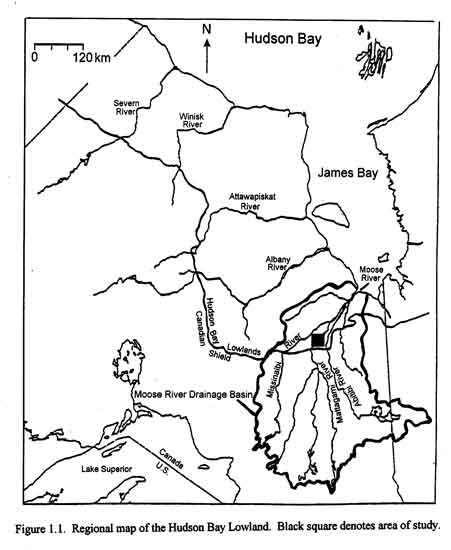
The
Mattagami River and Adam Creek are part of the Moose River drainage basin, which
flow northward, emptying into James Bay. Hydroelectric dams were built on the
Mattagami River by Ontario Hydro in 1963 at locations on the Precambrian Shield
rear the boundary with the Hudson Bay Lowlands. The southernmost of these dams
has a headpond to store water for dam use. When the ice and snow are melting
during spring freshet, the headpond is not able to contain the excess water that
has to be diverted through an emergency spillway, Adam Creek. The creek rejoins
the Mattagami River, 34 km downstream, 17 km below the last dam.
During the spring, a large volume
of water is rerouted through Adam Creek each year, up to 4500 m3/s.
The banks of the last 13 km of Adam Creek are composed of Pleistocene till and
other soft sediments of the Hudson Bay Lowland and so they are subject to
erosion. To date it has been estimated that over 52 million m3 of
sediment has been eroded from the creek. Approximately 2.5 million m3
of that material is deposited at the junction in the four gravel bars consisting
predominantly of coarse material: cobbles and pebbles with lesser boulders and
sand. Such coarse material comprises less than 5 % of the total volume of
material eroded from the creek. The remaining 47.5 million m3 of sand
and finer material is transported further downstream.
The main body of the gravel bars is believed to have formed during the
first few large floods following river impoundment and spillway use when
enormous amounts of erosion occurred along the Adam Creek spillway. Since then,
various sections of the bars have been reactivated by subsequent floods, and
have undergone numerous cycles of erosion and redeposition. Presently, the
junction bar is lobate in form and is comprised of three large chutes that
funnel flow from Adam Creek into the Mattagami River. The first two side bars
are very similar in form. Both bars have an older section of the bar now seldom
inundated, secondary chutes with chutes bars terminating onto the upstream
section of the bars, a side channel separating the bar from inner bank, and a
lower bar area which is reactivated more frequently than the higher older
section. The third side bar slightly differs in that it is much lower in
elevation and contains slightly finer sediments.
The alternating pattern of the gravel bars developed because of the
formation of low velocity, flow separation zones, within the confluence area
modifying this reach of the Mattagami River from a long wavelength, meandering
channel to a shorter wavelength, deeper thalweg bounded by the gravel bars.
|