|
2002, M.Sc., 192 pp.
SUBAQUEOUS ICE MARGINAL LACUSTRINE
SEDIMENTATION IN PART OF LAKE ERIE, ONTARIO CANADA
OAKES M.
 A
detailed study was conducted, through sedimentary facies analysis of basinal
deposits, to achieve a better understanding of sedimentation processes and
events occurring in front of an Upper Wisconsinian submerged glacial terminus in
the Great Lakes region. The stratigraphy and sedimentology of the deposits
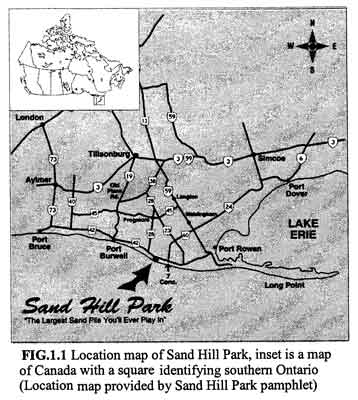
exposed along the north shore bluffs of Lake Erie, from Sand Hill Park to Port
Burwell, were studied with detailed analysis of a 2 km-long section proximal to
the glaciolacustrine end moraine. Regionally the deposits are characterized by
an overall coarsening upward succession, which change from till at the base. The
till is sharply overlain by clay, silt, and sand rhythmites, followed by a sand
unit and is unconformably overlain by low-angle cross- beds and planar laminated
sand with occasional high angle cross-beds. The deposits are capped by aeolian
sand that locally develops into large cliff-top dunes. The succession .has been
ascribed to and referred as the "Jacksonburg Delta" that developed
13,360±440, yrs B.P. A
detailed study was conducted, through sedimentary facies analysis of basinal
deposits, to achieve a better understanding of sedimentation processes and
events occurring in front of an Upper Wisconsinian submerged glacial terminus in
the Great Lakes region. The stratigraphy and sedimentology of the deposits
exposed along the north shore bluffs of Lake Erie, from Sand Hill Park to Port
Burwell, were studied with detailed analysis of a 2 km-long section proximal to
the glaciolacustrine end moraine. Regionally the deposits are characterized by
an overall coarsening upward succession, which change from till at the base. The
till is sharply overlain by clay, silt, and sand rhythmites, followed by a sand
unit and is unconformably overlain by low-angle cross- beds and planar laminated
sand with occasional high angle cross-beds. The deposits are capped by aeolian
sand that locally develops into large cliff-top dunes. The succession .has been
ascribed to and referred as the "Jacksonburg Delta" that developed
13,360±440, yrs B.P.
The detailed analysis of the more
proximal deposits to the ancient glacial margin has revealed complex sedimentary
patterns. The glaciolacustrine succession within 400 m of the glacial terminus (ABBE)
is first characterized by lenses of till and silty sand found in the lower
units, followed by thick (up to 5 m) ripple drifts, alternating with beds of
planar laminated and ripple cross-laminated sand with locally deformed (loading
structures) lenses of pseudo-massive sandy silt. This succession represents
hyperpycnal flow deposits derived from large outwash floods flowing in front of
the glacier and/or from the glacier itself as suggested by the occurrence of the
pseudo-massive lenses. Western glaciolacustrine sediments are similar in
thickness, but are characterized by a complex juxtaposition of foreshore,
heavy-mineral bearing planar laminated deposits, with upper shoreface rhythmites
of planar laminated sand alternating with ripple cross- laminated sand.
The western succession (ABBW)
may have formed diachronously from the eastern, (ABBE) succession.
One possibility is that ABBW formed while the glacier terminus was
located in a western position while shifting deltas and shore deposits were
active. The ABBE succession developed when the glacier retreated to
its eastern, more stable position. The deeper water facies of ABBE
may have resulted by a depression caused, in part, by the glacier weight, but
mostly because the original shoreline may have been embayed and the present
bluffs sections, exposing a more distal glaciolacustrine setting. The top sand
unit with predominant low angle cross-beds represent, on the whole, a shifting
shoreface setting possibly locally affected by braided sandy channels. Upon the
lowering of the glacial lake level, the sand was reworked into aeolian systems
eventually capped by (mainly) Brunisolic soils. Intense human exploitation of
the area during the last two centuries has all but disrupted the dune features,
except near the bluffs where cliff-top dunes are locally still active, fed by
sand eroded from the face of the bluffs.
|