From Code to Community: How W3S is Democratizing Global Weather Data
Building a Bridge Between Data and Impact
In the world of hydrological and water quality modelling, weather data plays a critical role in simulating real-world conditions. Accurate precipitation and temperature records are essential for forecasting floods, assessing droughts, predicting water quality changes, and managing agricultural resources. However, while elevation, land use, and soil data are readily available worldwide, reliable weather data—especially for precipitation and temperature—remains difficult to obtain, particularly in developing and under-resourced regions.
During the COVID-19 lockdowns, Dr. Prasad Daggupati—an associate professor in the University of Guelph’s School of Engineering—found himself distanced from his usual teaching and lab work. The unexpected pause offered time to reflect on long-standing challenges in his field, particularly the global gap in access to weather data. In response, he set out to build a web-based platform that would help bridge this divide. The goal was to make high-quality weather data freely and easily accessible to researchers, students, and professionals around the world—especially those in regions where data access is limited. Ensuring that the platform was not only user-friendly but also cost-free was essential, as one of its primary audiences includes students and early-career researchers.
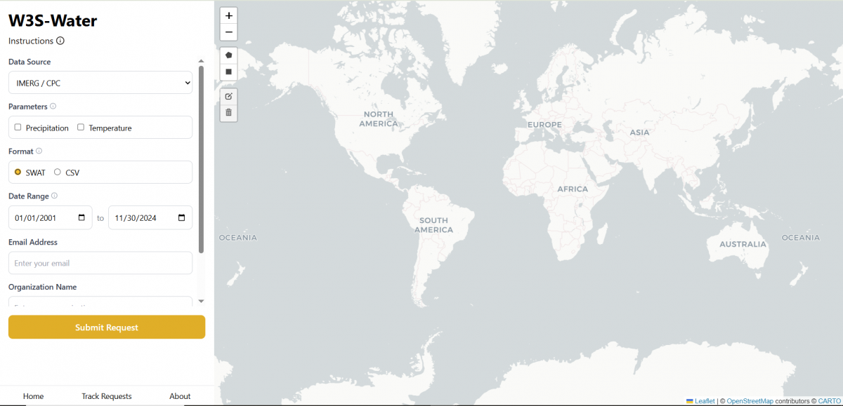
The result was W3S – the Watershed Weather Web Service. Designed to be both intuitive and powerful, the platform allows users to select any custom-defined region on a global map by drawing a bounding box—enabling highly localized data extraction. Users can then download daily precipitation and temperature datasets from 2001 to near real-time. These datasets are available in formats compatible with widely used hydrological models such as the Soil and Water Assessment Tool (SWAT) and the Hydrologic Engineering Center’s Hydrologic Modeling System (HEC-HMS), making it easy to integrate W3S outputs into existing workflows.
“Our goal was simple: make it easy. Students or researchers shouldn’t have to struggle with complex files or massive datasets just to begin modelling,” says Daggupati.
“We wanted a tool that was free, intuitive and globally accessible. We see this as a contribution to the global scientific community.”
From a Lockdown Idea to a Global Success

The project quickly gained momentum as Dr. Daggupati collaborated with postdoctoral fellows and graduate students to bring his idea to life. They developed W3S by linking it to global reanalysis datasets—specifically NASA’s Integrated Multi-satellite Retrievals for GPM (IMERG), which provides high-resolution precipitation data, and NOAA’s Climate Prediction Center (CPC) datasets, which supply global temperature and climate data. These sources offer near real-time, satellite-based weather information, enabling W3S to deliver consistent, reliable data even in regions where on-the-ground weather monitoring is limited or unavailable.
Instead of downloading massive volumes of data in advance, which puts intense demand on institutional servers, when a user requests weather data for a region, the platform dynamically fetches and processes it from NASA servers, formats it, and emails a download link—all in near real-time.
Today, the tool has over 4,000 unique users from dozens of countries, with demand in Africa, Asia, and South America, where weather data is lacking.
Behind the Scenes: The Unsung Heroes
Built using a combination of Python and Shiny, the platform dynamically connects to satellite data sources, processes complex file formats and delivers them in a usable form—without users needing significant technical expertise.
According to Dr. Daggupati, the University of Guelph’s School of Engineering IT team—Matthew Kent, Joel Best, and Bogdan Bunescu—were instrumental in integrating the platform with university servers and ensuring robust cybersecurity throughout the development process.
“Nothing like this would have been possible without the team’s tireless support,” Daggupati says.
“They worked with us patiently, especially when our servers were overwhelmed early on. Their role deserves to be spotlighted.”
Empowering Students and Looking Ahead
Undergraduate research assistants including Leo Banton are critical to the project, both maintaining and expanding W3S, which also provides them with hands-on experience. The team’s next steps are to incorporate near real-time dynamic weather data and new data layers to enhance usability for a wider range of climate models and decision-support tools.
“This was built with heart. And it’s available at no cost to anyone—from graduate students in Ethiopia to research teams in Brazil—because that’s how science should be.”