Research Project Updates
New and ongoing projects in 2024 are funded by MECP, OMAFRA and NSERC, and focus on chloride transport via groundwater pathways to the Great Lakes, nitrate transport under extreme storm events; phosphorous transport in groundwater and streams; and groundwater-tile drain interactions.
A few examples of recent and past projects include the following:
1. Agricultural N loadings to hydrological systems: Assessing the impacts of climate change
- 2021-2025
- Funded by OMAFRA (Ontario Agri-Food Innovation Alliance)
- Theses:
- Juan Arce-Rodriguez (MASc): Nitrogen dynamics conceptualization in a sand plain aquifer in the Lake Erie Basin
- Christina Zeuner (PhD): in progress
Project Summary/Update:
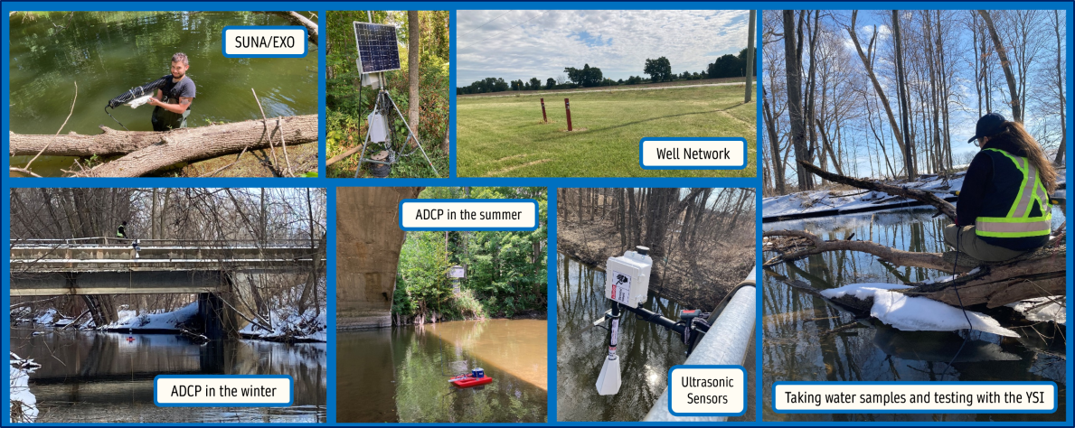
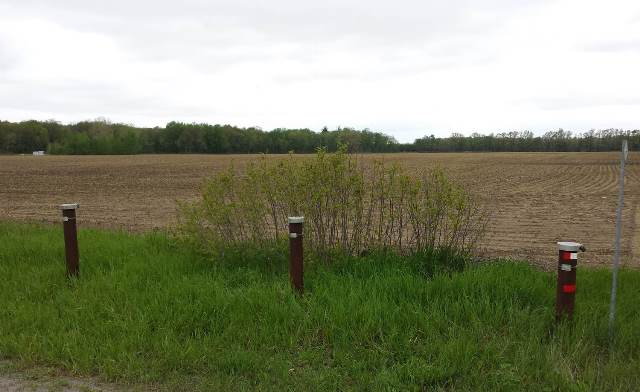
Rural watersheds in southern Ontario are experiencing water quantity and quality stress; this will be magnified by climate change. This project addresses climate change resiliency in Ontario’s Agri-Food sector by assessing storm event driven nutrient loadings from agriculture to stressed watersheds. This is accomplished through a field and modelling study using a well-instrumented research site in southwestern Ontario (Lower Whitemans Creek). An integrated (surface and subsurface) hydrological model (SWAT-MODFLOW software) was previously developed to understand long-term source availability for agricultural production enhanced or limited by groundwater. For this new research, N in soils, surface water and groundwater are quantified at the site, for storm events and seasonal variations. The SWAT-MODFLOW model is used to simulate N mobilization and transport in the hydrological system under expected future conditions. Higher intensity storm events, shorter and warmer winters, dryer summers, and more variable inter-year meteorological conditions are considered. In late 2023, most of the field data has been collected, and the numerical modelling is being conducted.
2. Groundwater-surface water interactions and agricultural nutrient transport in a Great Lakes Basin clay plain system
- 2018-2023
- Funded by OMAFRA (Ontario Agri-Food Innovation Alliance) and MECP
- Theses:
- Ceilidh Mackie (MASc): Groundwater-Surface Water Interactions and Agricultural Nutrient Transport in a Great Lakes Clay Plain System
- Sarah Rixon (MASc): Agricultural Nutrient Transport Through Various Water Pathways in a Great Lakes Clay Plain System
- Elisha Persaud (PhD): Understanding Watershed Functioning and Vulnerability in an Intensively Managed Agricultural Landscape
- Scott Gardner (PhD): Hydrologic, Sediment and Nutrient Dynamics in an Intensively Managed Agricultural Landscape
- Sarah Rixon (PhD): in progress
- Ahmed Elsayed (postdoc): in progress
Project Summary/Update:
Non-point source agricultural contamination (phosphorus and nitrogen) is a serious concern for surface and groundwater quality within the Great Lakes Basin (GLB), with severe associated environmental and ecological implications. The roles of groundwater-surface water interactions and movement of stream sediments in nutrient transport in agriculturally-dominated areas are currently not well understood. The purpose of this research is therefore to investigate the spatial and temporal evolution of phosphorus and nitrate in various hydrological pathways and stream sediments in a typical clay plain system in the GLB.
This research aims to use field-based data collection to help to fill the knowledge gaps that exist concerning nutrient transport through the surface water and groundwater interfaces and the hydrogeological processes influencing this transport in clay dominated settings, typical of the GLB. The subsequent research objectives are to:
-
Characterize the spatial distribution and temporal evolution of P and N in the shallow groundwater/streambank, stream and streambed over multiple growing seasons;
-
Relate the observed concentrations to watershed characteristics (e.g. land use) and hydrological patterns;
-
Model the effect of future changes in hydrologic regime and agricultural practice on the spatiotemporal distribution of stream/streambed P; and
-
Develop a conceptual model of the geological and hydrological factors responsible for the transport and fate of agricultural P and N to GLB tributaries (via groundwater discharge, overland flow, tile flow) in a typical clay plain setting.
Monthly collection of water (groundwater, surface water, tile water, and hyporheic water) and sediments for water quality analyses (primarily phosphorus and nitrogen species) from five study sites throughout the watershed is conducted. Field research (water and sediment sample collection) and mathematical modelling will continue to be performed to investigate contaminant inflows/transport through the groundwater-surface water interface and determine how the contaminated sediments move downstream in order to better understand processes that contribute to contamination of GLB tributaries by nutrients in agricultural subcatchments.
Thus far, project results suggest that tile drainage water and surface runoff are the main transport pathways for agricultural nutrients in the watershed, with varying influence on surface water quality throughout the year. Groundwater is likely not a significant source of nutrients of to the stream due to clay-rich soil and abundant tile drainage systems in the watershed. Instream loading of phosphorus from streambed sediment may have a critical impact on water quality in the summer months. Further monitoring of this nutrient delivery mechanism is essential to understand overall nutrient transport dynamics in the watershed.
Best management practices (BMPs), such as conservation tillage practices, in the watershed have been linked to water quality observations, particularly elevated dissolved phosphorus concentrations, in the stream. Consequently, BMPs in the watershed should be refined to improve water quality in the area.
Provincial agricultural and environment ministries (OMAFRA, MECP) will benefit from the project results for the development of future research directions or policies for water resource protection related to impacts of agricultural practices. Ontario conservation authorities and landowners in the area can integrate the new knowledge in watershed conservation, restoration, and best management practices.
3. Changing agricultural landscapes and groundwater quality in sensitive aquifers
- 2014-2018
- Funded by OMAFRA, GFO, DFO, OFA, CFI
- Theses:
- Scott Gardner (MASc): Groundwater Nitrate in Three Hydrogeologic Settings Throughout Southwestern Ontario
- Shoaib Saleem (PhD): Impacts of Future Climate and Agricultural Land Use Changes on Groundwater Nitrate Concentrations in Southern Ontario
- Related study: Graeme MacDonald (MASc): Developing Novel Techniques for Measuring In Situ Groundwater Nitrate Concentrations, Vertical Geochemical Profiling, and Real-time Remote Groundwater Quality Monitoring
Project Summary/Update:
4. Impacts of alkaline stabilized biosolids application on fate and transport of emerging substances of concern in agricultural soils, plant biomass and drainage water
- 2014-2016
- Funded by CWN, Walker Environmental, NSERC
- Thesis: Carolina Klabunde (MASc): Potential impacts on groundwater quality in a fractured sedimentary bedrock aquifer from biosolids application on agricultural fields
5. Improving crystalline bedrock aquifer conceptual models using novel discrete fracture network methods
- 2014-2020
- Funded by NSERC
- Thesis: Elisha Persaud (MASc): Innovative Application of FLUTe™ Liners for Cross-Hole Hydraulic Testing in Crystalline Bedrock Aquifers
6. Source water protection planning for First Nations communities
- 2014-2022
- Funded by RBC and NSERC
- Theses:
7. Groundwater use for agricultural production - current water budget and expected trends under climate change
- 2015-2019
- Funded by MAPAQ-OMAFRA
- Thesis: Ryan Osman (MASc): Water use conflict: a characterization and water quantity study in an agriculturally stressed subcatchment in Southwestern Ontario
8. Presence and fate of neonicotinoids in groundwater resources in Ontario
- 2015-2017
- Funded by OMAFRA-UofG Partnership
- Thesis: David Browne (MASc): Neonicotinoids in Groundwater: Presence and Fate in Two Distinct Hydrogeologic Settings in Ontario, Canada