Geographic Information Systems
Case Study
Flax in Waterloo County, 1861-1871
This case study joins the 1861 Canadian Census to a modern map of lots and concessions and uses the 1861 Tremaine map of Waterloo township, Canada West, to find addresses and check for historical accuracy. The data it displays are flax production figures, but they could just as easily be information about people or other produce.

This map in its paper format is not dynamic. One could not put a finger on a specific lot and identify its name, location, or information about its residents or yields, without first consulting other sources or other parts of the map. Nor could one readily visualize the elevation of the physical environment to appreciate surface characteristics such as hill shade or examine water run off trends and the suspicious relationship between disease and the location of agricultural waste and wells. By digitizing the map and linking it with statistical and geospatial data in a GIS a researcher can do this more easily.
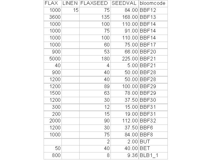
In a GIS maps are dynamic, because behind every layer is an attribute table made up of records described by the information in the fields. The example below shows the record for the lot selected in blue on the map.

In some cases, having a georeferenced historical map helps clarify problems with other historical sources. For example, in Wilmot township, Canada West, the 1861 Census recorded the names of major east-west roads as concessions, and it did not specify whether residents lived to its north or south. This is a problem, because every lot in our modern boundary map has a unique attribute and some residents recorded in two different locations in the census have the same lot and concession number. This portion of the Tremaine map recorded the names of residents and when overlaid on our map it becomes possible to differentiate between residents on each side of a concession like Snyder’s Road.

In order to join other information about the lot to the map, there must be a common field between the attribute table and the new information. In this case it is a combination of the lot and concession number.
The information in the table below can be joined to the following map because the attribute table attached to the lots layer and the statistical table below created by a researcher both have a field containing the unique value for each lot; in this case it has been called “bloomcode,” because the codes for each lot were named by historian Elizabeth Bloomfield.

With the historical data joined to the map it is easy to represent the amounts of flax produced by farmers in these townships in 1861. Other sources state that there were three flax mills in this county in 1861, and they have been marked on this map. The patterns of high flax production correlate closely with the locations of the mills necessary to manufacture the flax fibre and seed.

In 1871, the map demonstrates that production had shifted almost entirely westward, and the highest flax growing lots in 1861 were not major flax regions ten years later. This answers some questions, but raises many more. Studying history with GIS is a good way to recognize trends that are not evident in other sources.

GIS software can draw a buffer around any given point, in this case the location of the nearest flax mill, and calculate the proportion of flax produced within a certain distance to the mill. GIS calculates data that are completely within the buffer unless it is instructed to include data partially included in the buffer. It is important to recognize that the software recognizes the data attached to the polygons (lots) and not the representations of those data (circles). Therefore, in this case only five lots containing flax are completely within the buffer and an additional nine are partially inside the buffer.

It is often helpful to overlay different representations of data in a GIS to identify spatial patterns. For instance, the above table showing producers of flax and homespun linen suggests there is hardly a correlation between flax farmers and those households making domestic use of the commodity. However, the following map of a township in Waterloo County indicates that this relationship did exist in some areas, and probably in the contiguous lots of the township to the south. This township was apparently anomalous, and the spatial representation would be more useful if combined with a regression analysis of a wider area. Again, GIS has provided more questions than answers, i.e why did farmers in this particular area use some of their flax to make linen, and these questions are extremely useful for researchers.
