From Tallgrass to Tundra: Researchers Find a Better Way to Measure Grassland Cover and Estimate Carbon Storage
When you can’t be an expert on everywhere, you find experts from everywhere! This is exactly what happened on a recent study led by Dr. Andrew MacDougall in the Department of Integrative Biology that set out to improve how grasslands are measured.
Much of the world’s land cover is now measured remotely through satellite imagery, which has dramatically improved our ability to characterize the Earth’s land surface. But despite the relatively high-resolution of today’s remote imaging, different land mapping programs suffer from inconsistencies and errors in how they classify different types of land cover.
“Spatial mapping of land cover based on satellite imagery is increasingly being used to quantify global sustainability and inform climate solutions,” explains MacDougall. “As such, even small errors can add up to enormous impacts when modeling on a global scale.”
In fact, previously published estimates of total global grassland cover vary by tens of millions of kilometres squared. This in turn leads to vastly different estimates of carbon uptake and storage in soil, an important indicator of climate health and resilience. It’s also a critical measurement in determining if the world is on track to meet the goal of carbon neutrality by 2050.
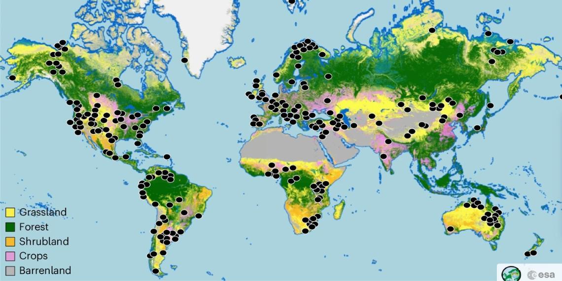
To combat this issue, the team — consisting of 157 grassland researchers from 60 different countries around the world — set out to determine where errors in land mapping commonly occurred. A unique element of their approach was incorporating local knowledge from team members to help validate imagery in different types of grasslands and regions. Explains MacDougall: “It was important to include researchers from everywhere because they know their own environments best.”
The team’s “ground-truthing” generated a validated reference system that was then used to recalibrate the global measurement of grassland.
Surprisingly, they found that grassland coverage was only about 60% of that which had been reported in literature. Many previous studies had reported that 40% of land globally was covered in grassland, but the team found that the true value was closer to 23%.
Grasslands are critical for all aspects of human sustainability, from food production to culture and well-being. They are also a hub for biodiversity, including large numbers of native plants and many of the world’s most at-risk mega-fauna. Roughly 850 million people around the world rely on grasslands for their livelihood, but it’s a class of ecosystem that is highly vulnerable to anthropogenic disturbance and degradation. That’s because they are the easiest to clear for development, contain smaller species more vulnerable to the effects of pollution, and are easily damaged by even just the simple presence of humans.
“There has been a recent push to measure everything remotely and save money, time, and person power, but when funding for important causes like poverty and sustainability is based on these measurements, we have to get it right. If not, support doesn’t go to where it’s most needed,” says MacDougall.
In addition to MacDougall, the research team including major contributions from Food From Thought MSc student Bryce Vanzant, Dr. John Sulik, Department of Plant Agriculture, and Dr. Matthias Siewert, Umeå University, Sweden.
Read the full study in the journal Nature Ecology and Evolution.
Read about other CBS Research Highlights.